


TS. GS. DR CHONG WEI SHENG
Institut Marin Borneo (IMB)
Universiti Malaysia Sabah
Photos credit: Dr Fikri Amal & Dr Chong Wei Sheng
Protecting seagrass and marine habitats in Sabah
“My vision is to bridge the gap between advanced technology and local stewardship”
The rich biodiversity around the islands of Pom-Pom and Mabul, on the East coast of Sabah is under threat as their marine areas are not part of a formal protection area, despite being located in the Coral Triangle and close to the world famous Sipadan island. The islands are known for their dense seagrass meadows and interconnected habitats such as coral reefs and mangroves, which together harbour valuable marine life such as horseshoe crabs, flamboyant cuttlefish, blue ringed octopus the critically endangered hawksbill turtle and dugongs, making them renowned dive sites and biodiversity hotspots. Sightings of migratory manta rays and whale sharks have also been reported around the islands. Whilst all the marine habitats are important, seagrass meadows are particularly vulnerable as they are often overlooked and are important foraging grounds for dugongs, sea horses and the many sea turtles found there. Whilst Pom Pom Island features a relatively intact marine ecosystem with lower levels of tourism compared to other islands, Mabul Island represents a critical area where local coastal communities live in close proximity to seagrass ecosystems and depend directly on them for food and livelihood. Here anthropogenic pressures are much more evident and alarming.
Threats
The seagrass meadows and coral reefs have already experienced damage from unregulated blast fishing, marine debris, tourism and unregulated boat traffic. Land clearing for resort development has also lead to increased sedimentation. As these habitats aren't formally documented in a way that can be usefully processed by the authorities, little regard is given to preserving them.
Damage to seagrass can result in severe coastal erosion, loss of biodiversity eg vital fish nurseries, degraded water clarity, and the release of stored carbon back into the environment.
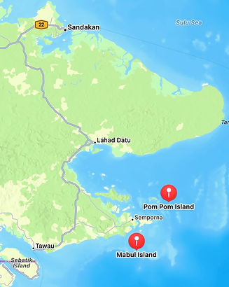


Pom Pom Island

What needs to be done - “I aim to provide the scientific foundation required to integrate these meadows into Marine Protected Area (MPA) networks”
Dr. Chong and the Institut Marin Borneo (IMB) team at the Universiti Malaysia Sabah (UMS) for which he is technical lead, aims to achieve formal protection for these areas by undertaking the first step: mapping the seagrass meadows and their associated ecosystems - mangroves, coral reefs, seaweeds and intertidal mudflats - and creating an integrated 3D model of the habitats, the most accurate to date. They will also submit to the planning authorities, data about the biodiversity found there and on the economic value the habitats bring to the communities, so as to make a more complete case for formal protection. Hand in hand, they will set up an initiative with local fishing villagers to monitor the seagrass meadows and restore damaged seagrass using a stapling replanting method. In this way, they hope to encourage the community to become the primary guardians of their own marine heritage. The work will be carried out in collaboration with local partners TRACC (Tropical research and Conservation Centre) at Pom Pom Island, and Scuba Junkies and Mabul Youth on Mabul island.
To help the project succeed, Rainbow Runner Asia, an established diving equipment supplier committed to supporting marine conservation and ocean sustainability, and Mares, the dive equipment manufacturer have agreed to donate their equipment.

Mabul Island
Ts. Gs. Dr Chong Wei Sheng
Dr Chong brings a rare ability to advance marine conservation in Malaysia through his technical knowledge of cutting-edge mapping systems. Marine ecosystems mapping here is many years behind the latest methods used in countries like Japan, China and Australia. In his position as technical lead, this young award-winning researcher guides his research team at IMB in the adoption of the latest geo-spatial mapping technology that uses side-scan sonar, underwater drones, satellites and *UAVs to create *GIS maps of the seabed. Used together with ground truthing and spectral imaging, this not only provides the most complete and database compatible information to decision makers but also shows how the critical marine habitats are linked through their shared biodiversity. Dr Chong, who is also a senior lecturer at UMS makes sure he continually passes on this knowledge to a new cohort of young researchers. Dr Chong and his team have mapped a significant portion of seagrass meadows across Sabah. His long term goal is to establish a statewide database of all seagrass habitats and to build awareness of their importance to marine life. (*GIS -Geographic Information System; UAV- Unmanned Aerial Vehicle; Ts.- Professional Technologist; Gs. - Certified Professional Geospatialist)


Future plans - following through with protection
This project only represents Phase 1 of a conservation strategy for the islands, covering ecosystem mapping, baseline survey, citizen science and geodatabase establishment. Future phases of the project will involve strengthening community skills so that conservation can be carried out independently, setting up waste management and sanitation initiatives to reduce land-based impact on marine habitats and utilizing the baseline database established in Phase 1 to advocate for official habitat protection and informed coastal management policies alongside local management authorities and partners.
What the Biji Alam Award will fund
-
Mapping expenses for the seagrass meadows and associated marine habitats around Pom-Pom and Mabul islands - will use 40% of the award funds
-
Community engagement and training - 25%
-
Data processing and submission – 20%
-
Restoration materials - 15%